
Neal Halstead and Eric Sievers (Wildlands Conservation, Inc.)
Florida is the third-largest state in the U.S. by human population and has the highest net migration rate in the country, with an average of >1,000 people moving to the state per day from 2020 to 20251. This leads to direct conflict between development to accommodate the demands of a rapidly growing human population and conservation efforts for tortoises displaced by development. Because tortoises are a state-designated threatened species, the Florida Fish and Wildlife Conservation Commission (FWC) requires relocation permits to move tortoises from any potentially occupied burrows that occur within 25 feet of construction footprints and associated development areas. Over 25,000 relocation permits have been issued by FWC since 2009, resulting in the relocation of over 110,000 tortoises.
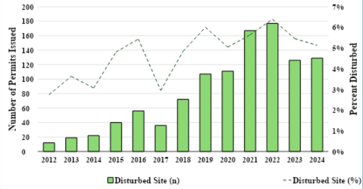
When development activities commence where gopher tortoises occur without first obtaining a relocation permit (and are reported to the FWC), a disturbed site permit is required. It is difficult to determine how many tortoises might be lost as a result of unpermitted site disturbance because not all unauthorized impacts are documented, and not all tortoises at disturbed sites can be recovered. At a minimum, disturbed sites incur project delays and additional financial costs to the developer or property owner, many of whom are unfamiliar with gopher tortoises or the regulations protecting them. The level of compliance with the FWC Gopher Tortoise Permitting Guidelines (GTPG) appears to be high, with a low percentage of the total relocation permits issued identified as disturbed site permits. However, the proportion of relocation permits issued for disturbed sites has increased over time (Figure 1). This is especially a cause for concern, as the overall number of permits issued annually has increased over the same period.
Habitat suitability models for gopher tortoises have been produced multiple times using different methodological approaches. However, most of these efforts focus on identifying areas of high-quality habitat to assist with conservation management decisions. Unlike these previous models developed to identify the “best” habitat, our goal was to create a GIS model to map areas where gopher tortoises reasonably might occur. Because tortoises are so long-lived and resilient, they very often occur in areas that would not generally be considered as high quality. In fact, most relocation permits occur in such areas. Therefore, this model is explicitly intended to overpredict the potential occurrence of gopher tortoises to ensure appropriate survey measures are taken to comply with the GTPG.
Three recent models of potential gopher tortoise habitat include a rules-based model originally developed by Endries et al. in 2009 and updated by FWC in 20162 (Model A), a range-wide gopher tortoise habitat model published by Crawford et al. in 20203 (Model B), and an updated state-wide model produced by FWC in 20234 (Model C). We used binary output from each model that classified areas in Florida as either gopher tortoise habitat or not tortoise habitat and created a conglomerate model by overlaying the presence or absence of identified gopher tortoise habitat from all three models and combining them. We compared the coverage of each individual model and the conglomerate model to the locations of 18,623 gopher tortoise relocation permits issued by FWC between 2009 and November 2024. Each individual model included only 23% to 48% of these permit locations, and the conglomerate model included 60% of all permit locations, with only 12% of relocation permit locations identified as potential habitat by all three models (Table 1).
Table 1. Number and percent of 18,623 gopher tortoise relocation project locations that were located within each of three previously published models of gopher tortoise habitat, and a conglomerate model combining these models with three levels of model agreement. The level of model agreement for the individual models indicates how many project locations were shared between that particular model and: both other models (All 3 models), one other model (2 of 3 models), or is unique to that model alone (1 of 3 models).
|
Locations (18,623 total) |
||||
|
Model |
Total |
All 3 models |
2 of 3 models |
1 of 3 models |
|
A (FWC 2016) |
5,443 (29%) |
2,250 (12%) |
1,855 (10%) |
1,338 (7%) |
|
B (Crawford et al. 2020) |
9,030 (48%) |
2,708 (15%) |
4,072 (22%) |
|
|
C (FWC 2023) |
4,338 (23%) |
1,719 (9%) |
369 (2%) |
|
|
Conglomerate |
11,170 (60%) |
2,250 (12%) |
3,141 (17%) |
5,779 (31%) |
Because the purpose of this modeling exercise was to identify areas of the state where surveys should be conducted for the presence/absence of gopher tortoise burrows, we specifically wanted to increase the model coverage to include much closer to 100% of all permit locations. Therefore, we constructed a new model to account for the ~40% of permitted project locations that occurred in areas not identified as gopher tortoise habitat in the original conglomerate model. Wildlands used statewide land cover and soils data to build an additional rules-based model that increased the coverage of permit location data to 97% (18,121 permits) in the final model (Figure 2).
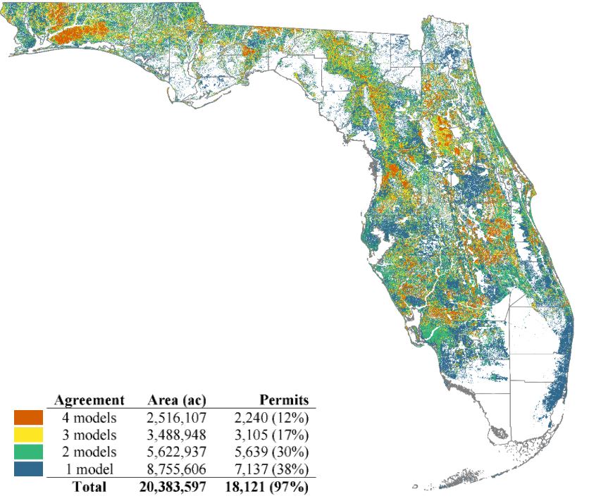
Dubbed the “Gopher Tortoise Probability Index”, this model indicates the level of agreement among the four input models of potential gopher tortoise habitat for any specific area in Florida, ranging from a value of 0 (no models identify a location as potential habitat) to a maximum of 4 (a location identified as potential habitat by all four models). It does not indicate whether gopher tortoises are actually present at a given location but implies a relatively high likelihood that habitat conditions are suitable for gopher tortoises to occur. Likewise, index values of 3, 2, or 1 indicate a decreasing level of agreement among the 4 input models in identifying an area as potential gopher tortoise habitat. This implies a decreasing probability of suitable habitat conditions for gopher tortoises at a given location. However, various combinations of the four input models could produce index values between 3 and 1, and these models are not equivalent in their parameterization. A more appropriate interpretation of these index values is that as the index value decreases, there is a higher degree of uncertainty in the possibility of potential gopher tortoise habitat being present at a given location. Finally, an index value of 0 indicates that none of the four input models identified an area as potential gopher tortoise habitat. However, because of inherent inaccuracies in data input layers and imperfections in habitat suitability models, a value of 0 for a given area does not guarantee that gopher tortoises or potentially occupied burrows are not present.
The Gopher Tortoise Probability Index can be accessed via the Florida Geographic Data Library (FGDL; https://fgdl.org/). The FGDL website hosts many other GIS models for the state of Florida and has a user-friendly map explorer in which users can add the Gopher Tortoise Probability Index layer and additional layers, such as municipal boundaries for simultaneous viewing. The raster data for the statewide Gopher Tortoise Probability Index model can also be downloaded directly from the FGDL website. Metadata associated with the model and a brief description of the model are also available from FGDL. The map can be directly viewed at: https://fgdl.org/fgdlmap/index.html?serviceName=GOPHER_TORTOISE_MODEL.
The goal in developing the Gopher Tortoise Probability Index was to provide local government staff and the public with an easily accessible GIS-based resource to assess the potential for gopher tortoise habitat (and therefore, gopher tortoise burrows) to be present at a site before development activities begin. The intention is for this resource to be used as a screening tool to help determine when a formal gopher tortoise burrow survey should be conducted at a site and whether a gopher tortoise relocation permit is required prior to commencing development activities. Only an appropriate survey conducted by a qualified FWC Authorized Gopher Tortoise Agent can be used to determine whether a gopher tortoise relocation permit is required for a project. Gopher tortoises and their burrows are protected by Florida state law wherever they occur (whether in mapped potential habitat or not), and a gopher tortoise relocation permit must be obtained from FWC before disturbing burrows and conducting development activities.
Acknowledgments
This project was funded by FWC contract CFP20232-A awarded to Wildlands Conservation, Inc. We’d like to thank the following individuals in particular: FWC Gopher Tortoise Program: Kate Richardson, Kyle Brown, Emma Rogers, Michelina Dziadzio, Amanda Mills; FWC Fish and Wildlife Research Institute (FWRI): Colin Shea, Mark Barrett, Chelsey Crandall, Phillip Rodgers; University of Florida GeoPlan Center: Tom Hoctor; FGDL: Alexis Thomas.
References
- United States Census Bureau. State Population Totals and Components of Change: 2020-2025. https://www.census.gov/data/tables/time-series/demo/popest/2020s-state-total.html Accessed 2026-07-01.
- Endries, M. et al. 2009. Wildlife habitat conservation needs in Florida. Fish and Wildlife Research Institute Technical report TR-15. Florida Fish and Wildlife Conservation Commission, Tallahassee, Florida. 178 p. [Gopher tortoise rules-based model updated 2016].
- Crawford, B.A., Maerz, J.C., and Moore, C.T. 2020. Range-wide habitat suitability maps for at-risk species in the longleaf system: U.S. Geological Survey data release. https://doi.org/10.5066/P92PZN7G.
- Barrett, M.A. 2023. Predictive habitat model (Maxent) for the gopher tortoise (Gopherus polyphemus) in Florida. Unpublished data. Center for Spatial Analysis at the Florida Fish and Wildlife Conservation Commission, Tallahassee, Florida.